|
Scalable map & customized driving directions...
View a scalable map and obtain detailed driving directions by clicking on any of the following sources:
- Bing (including a "bird's eye" view of the observatory)
- Google (displays a street level view of the MTO entrance along Marston Road, Md. 407)
- Mapquest
|
|
Satellite Photo...
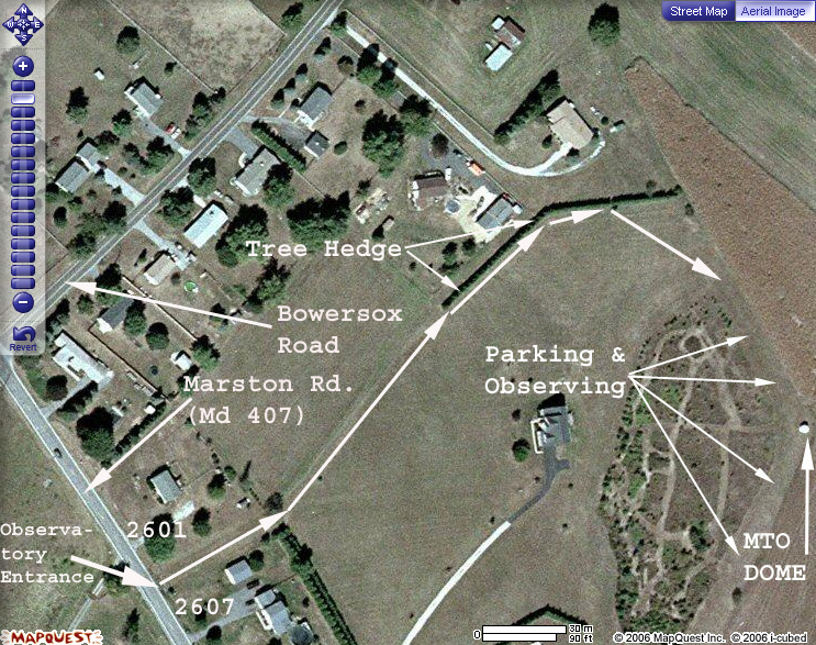
|
Click on image to view a satellite photo of the observatory grounds provided by Mapquest.com
North is at top in this satellite photo showing both Bowersox and Marston (Md. 407) Roads. The observatory structure is located near the eastern edge in the photo.
|
|
|
Bird's Eye View...
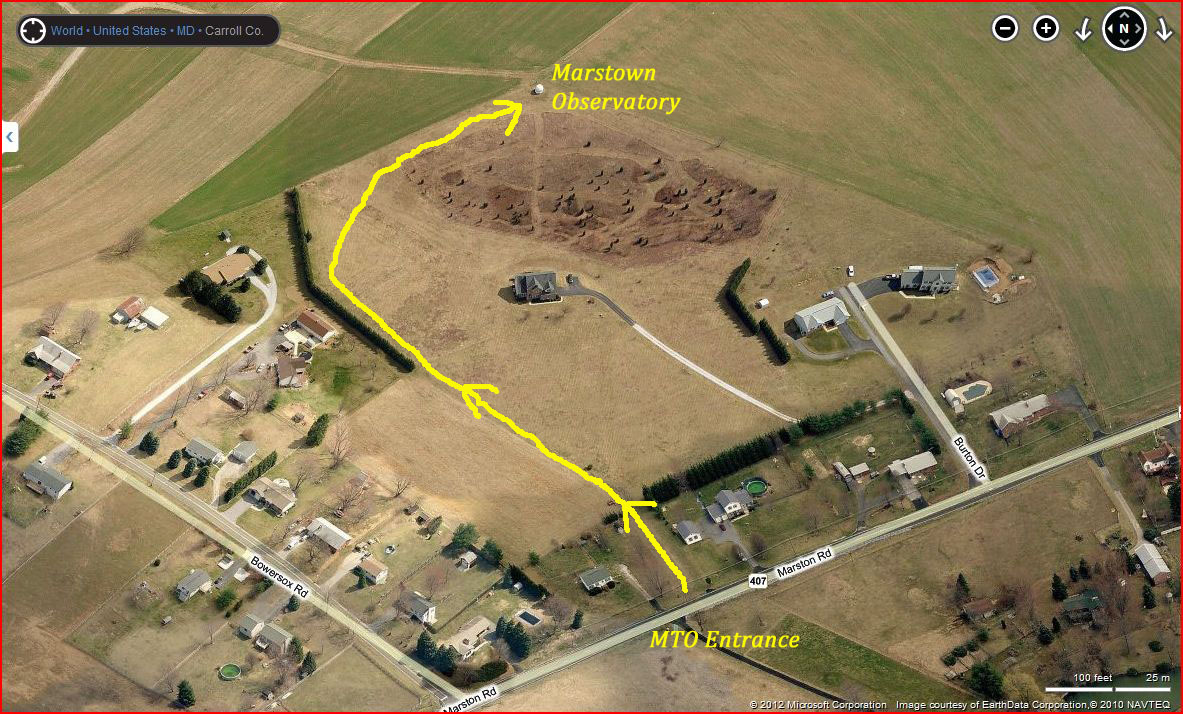
|
Click on image to view a bird's eye view of the observatory grounds provided by Bing.com
Unlike the Site Map below, north is to the left in the bird's eye view which shows both Bowersox and Marston (Md. 407) Roads. The observatory structure is located atop the hill near the upper edge.
|
|
|
Hiking Trails...
![[forest trails]](./images/Forestrails.jpg)
|
Click on image at left for an arial map of the forest's hiking trails.
Hiking trails in the nearby forest area are a source of wild mulberries, black berries, choke berries and others (when in season) or as a diversion during clear or cloudy times.
|
|
|
Topographic map...
|
Click here for a Trails.com link to display a 1:25,000 scale topographic map of the observing site! The red plus at the center of the map marks the spot.
|
|
|
From Westminster, Reisterstown, North Baltimore:
- Take Md. 140 to Md. 27.
(From North Baltimore first take I-795 west to Md. 140.)
- Take Md. 27 south toward Taylorsville.
- Turn west (right) on Md. 407 (Marston Road). The intersection is just prior
to a Little George's convenience store.
- Continue approx. 2 miles until you come to a green sign on the right side which says,
"Bowersox Rd." (If you reach Bowersox Road you have gone about 1/2 block too far;
turn around and go back.)
- Turn right onto a small blacktop apron about 10 feet before you get to the "Bowersox Rd." sign with a double post. The apron is
located between two houses whose addresses are 2601 and 2607 Marston Road.
- Keeping your headlights on, continue forward along the grassy lane between the two houses.
- Where the grassy lane ends, bear slightly left and continue forward.
- Eventually you will come upon the west end of a young tree hedge. Swing around the hedge to the right.
- Keeping the hedge on your left, follow it until you come to a tree which appears to have stepped away from the hedge. Bear toward the right and continue driving up hill.
- Once you see the dome, turn off your headlights and continue carefully
forward up the hill.
- Parking and observing will be along the left side of the driving path. The
observatory is near the crest of the hill.
- Consult the satellite image of the site for additional
landmarks in the area.
|
From Mt. Airy, Montgomery County, Howard County, and South Baltimore:
- Take Md. 27 North toward Taylorsville.
(From South Baltimore first take I-70 west to Md. 27.)
- Drive through Taylorsville (crossing Md. 26). Continue on Md. 27 approx.
2 miles and turn west (left) on Md. 407 (Marston Road). The intersection is
just beyond a Little George's convenience store.
- Continue approx. 2 miles until you come to a green sign on the right which says,
"Bowersox Rd." (If you reach Bowersox Road you have gone about 1/2 block too far;
turn around and go back.)
- Turn right onto a small blacktop apron about 10 feet before you get to the "Bowersox Rd." sign with a double post. The apron is
located between two houses whose addresses are 2601 and 2607 Marston Road.
- Keeping your headlights on, continue forward along the grassy lane between the two houses for about 200 feet.
- Where the grassy lane ends, bear slightly left and continue forward.
- Eventually you will come upon the western end of a tree hedge.
- Keeping the hedge on your left, follow it until you come to a tree which appears to have stepped away from the hedge. Bear toward the right and continue driving up hill.
- Once you see the dome, turn off your headlights and continue carefully
forward up the hill.
- Parking and observing will be along the left side of the driving path. The
observatory is near the crest of the hill.
- Consult the satellite image of the site for additional
landmarks in the area.
|
From Frederick County:
- Take Md. 26 East to Libertytown.
- Once past the town, turn north (left) onto Md. 31.
- Continue north on Md. 31 into Carroll County.
- Turn southeast (right) on Md. 407 (Marston Road), and continue on
through the little burg of Marston while staying on Md. 407 by turning left at the
3-way stop in the village center.
- Continue past Bowersox Rd about 1/2 block and turn west (left) onto a small blacktop
apron located about 10 feet beyond a highway sign held up by two posts located between two houses whose addresses are 2601 and 2607 Marston Road.
- Keeping your headlights on, continue forward along the grassy lane between the two houses for about 200 feet.
- Where the grassy lane ends, bear slightly left and continue forward.
- Eventually you will come upon the western end of a tree hedge.
- Keeping the hedge on your left, follow it until you come to a tree which appears to have stepped away from the hedge. Bear toward the right and continue driving up hill.
- Once you see the dome, turn off your headlights and continue carefully
forward up the hill.
- Parking and observing will be along the left side of the driving path. The
observatory is near the crest of the hill.
- Consult the satellite image of the site for additional
landmarks in the area.
|